
The Navigable System (a brief overview)
Navigation on the River Bann and Lough Neagh System stretches from 5 miles North of Coleraine at the mouth of the Lower Bann at Castlerock, to Blackwatertown in the Southwest, to Moneypennies Lock in the South on the presently closed Newry Canal South of Portadown and Antrim in the East. At present there are approximately 54 nautical miles (100km) of navigable rivers and 500 square km of navigation on Lough Neagh. The system is not really suited to craft needing more than 1 metre of water although there are quite a few pleasure boats drawing 1.5 metres with one at least drawing 1.60 metres. Lifting keel yachts are greatly favoured. Deep draft can lead to problems in late summer/early autumn when Lough Neagh is usually at it lowest. There are no airdraft restrictions on Lough Neagh which makes it a haven for sailing. The Lower Bann is restricted to an airdraft of 4.1metres (Coleraine Town Bridge subject to spring tides). The River Blackwater has an airdraft restriction of 2.55metres (Motorway Bridge) assuming Lough Neagh level of 12.5m O.D. (12.5 metres above Mean Sea Level Belfast). The Upper Bann has an airdraft restriction of 3.05metres (Motorway Bridge) assuming Lough Neagh level of 12.5m O.D. Lough Neagh Levels are published daily by the Department for Infrastructure https://www.infrastructure-ni.gov.uk/articles/lough-neagh-levels Essential equipment on the River Bann and Lough Neagh System are a copy of the Admiralty Chart 2163 (Lough Neagh), Chart 2499 (Coleraine) and the River Bann and Lough Neagh Pilot Book. Please study all pertinent when planning a journey.
Signage
There are three systems in use:
· IALA Maritime Bouyage System-Region A (Red to
port) system is used on the Lower Bann north of Coleraine Town Bridge.
· On the Lower Bann south of Coleraine Town Bridge
most of the dangers and shallows are marked by a semicircular red and white
sign with red denoting danger and white safe passage. This is also used on the Lough
Neagh Cardinal System.
· A modified version of the IALA system is used on
Lough Neagh. The cardinal marks are used in conjunction with the semicircular
red and white sign and are numbered clockwise from 1-47 starting at Toome Canal
entrance and finishing at Bamford Bank (see Admiralty Chart no 2163). For
further details on signage see page 72 of the River
Bann and Lough Neagh Pilot Book.
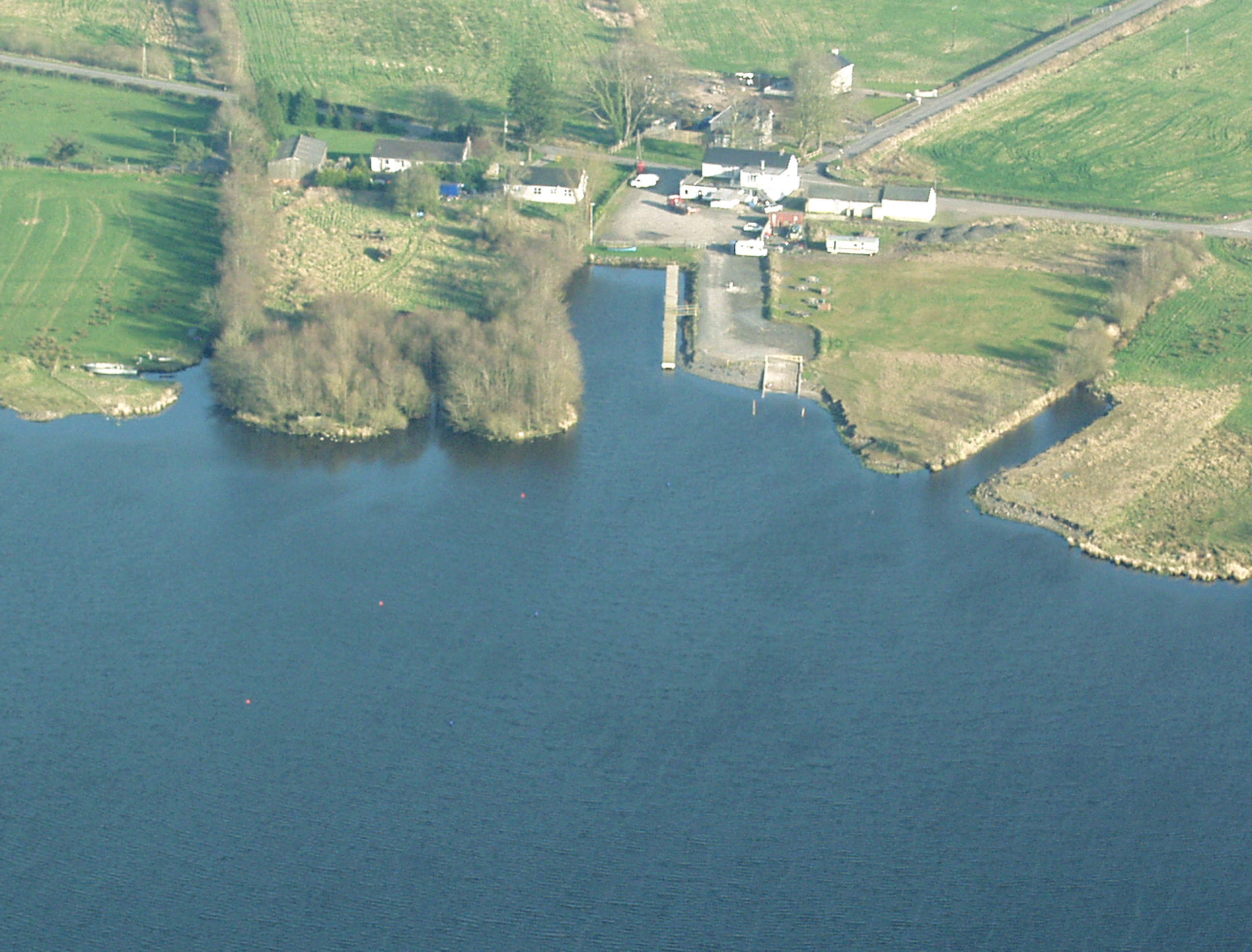
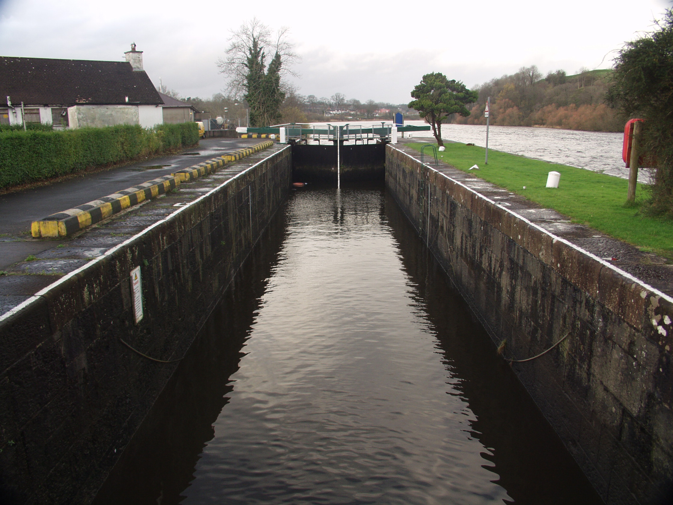
The Lower Bann The Lower Bann leaves Lough Neagh in the north east corner of Toome Bay dropping approximately 12.5 metres during its’ 33 nautical mile (60 km) journey to the sea at the Barmouth. Navigation and water levels are facilitated by a series of locks, weirs, floodgates and canals. The 5 sets of locks are operated by Waterways Ireland lock keepers. The river is maintained at a minimum depth of 1.55m but owners of boats with a draught of more than 1m are advised to contact the Waterways Ireland at Coleraine(028 70344342) for information on water levels, stoppages etc. This is important in late summer early autumn. Waterways Ireland publish a code of conduct for the Lower Bann copies of which can be obtained from Waterways Ireland, Coleraine (028 7034 4342). The Lower Bann is covered by 3 Ordnance Survey maps at 1: 50 000 scale. These are Sheet 14 - Lough Neagh, Sheet 8 - Ballymoney and Sheet 4 - Coleraine. The Bann Estuary can be entered from the sea at the Barmouth between Castlerock and Portstewart Strand marked by the East and West moles at the Barmouth. The entrance to Toome Canal lies to the south-east of Toome Floodgates with the channel entrance marked by port and starboard marks. There is also a white cairn on the west mole of the canal. It pays to inform the Lockeepers of your intended arrival as it makes life easy to be able to proceed into the chamber. All chambers are provided with boarding ladders.
Lough
Neagh
With a surface area of some 390
square km Lough Neagh is often described as an inland sea. The average depth of
Lough Neagh is 12 metres. The deepest part of the Lough is 29 metres, at an
area to the southwest of Skady Tower known locally as “the hole”. With few
exceptions the Lough shelves slowly to the shoreline. Safe water is usually
found by keeping at least 0.5km from the shore. An exception to this is the
east entrance to Toome Bay (known as Skady Tower) where safe water is not found
until over 1km from the shore.
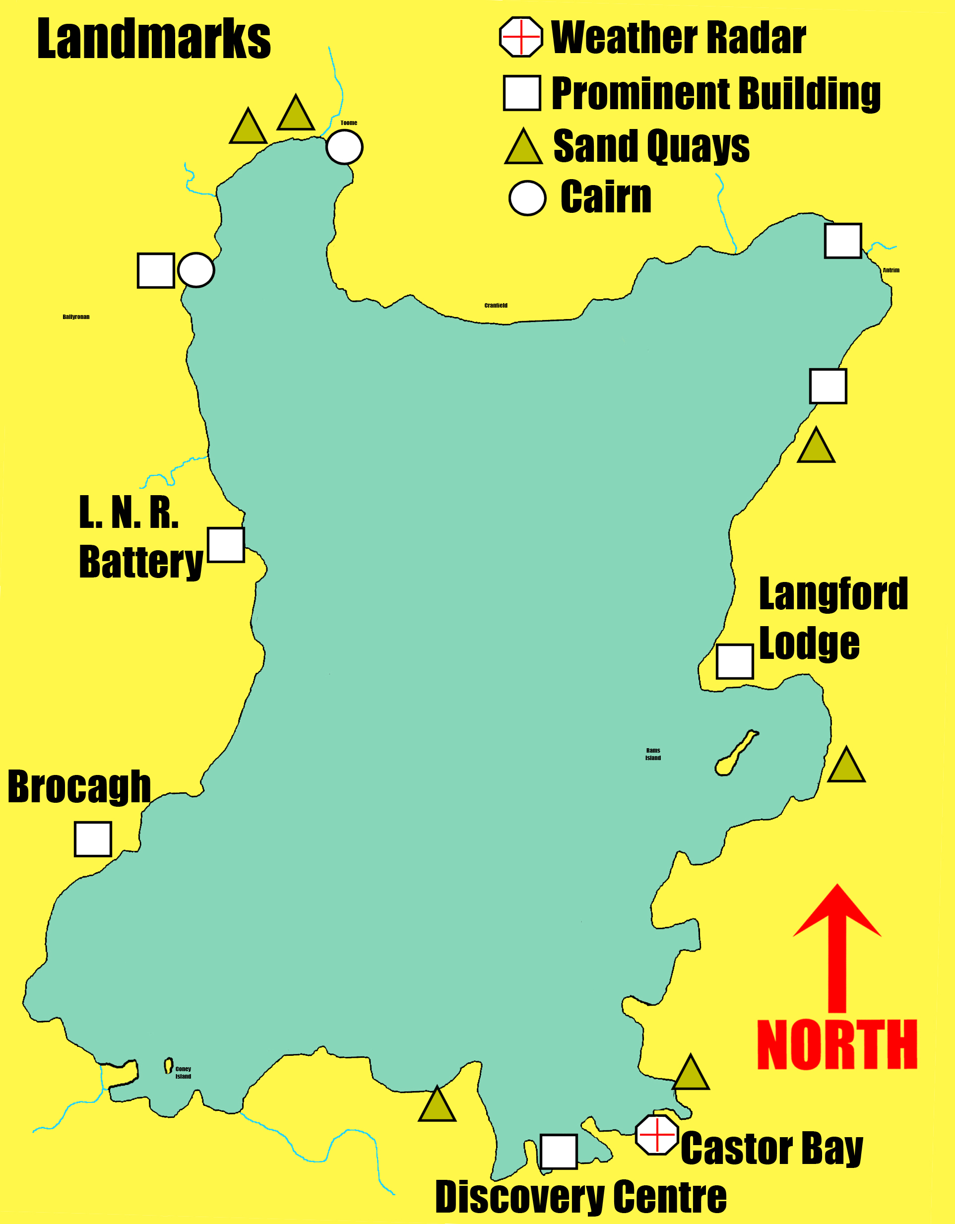
Having a horizon surrounded by
low-lying hinterland good landmarks are few and far between.
Natural
Landmarks of note are:
· Slemish (440metres in height) to the northeast
and the Sperrin Mountains to the northwest.
· Divis and the Blackmountain with their large
aerials can be seen to the east.
· Although a long way off, the Mourne Mountains
can sometimes be seen to the south.
· Manmade landmarks include large white sheds at
Langford Lodge (Gartree Point known locally as the Lodge).
· The Discovery Centre at Oxford Island (a large
building with a grey roof).
· The heaps of sand at the numerous sand quays
around the Lough (the majority of sand quays are marked on the Admiralty Chart
and are usually lit at night).
· The
remains of the Torpedo Platform close to the shore north of the entrance to the
Sixmilewater.
· The water abstraction tower at Dunore on the
eastern shore (this is usually lit at night surrounded by white lights and a
red light on top. · The weather radar mast at Castor Bay on the
southeast shore (this resembles a large golf ball).
· The floodgates at the mouth of the Lower Bann.
· The white cairn at the entrance to Toome Canal.
· The white cairn at the entrance to Ballyronan Marina
(the cairn at Ballyronan has a flashing orange light at night).
· The blue roofs of the bar and the fish factory
at the Battery Harbour near Ardboe on the western shore (the entrance to the Battery
is marked by port (red) and starboard (green) flashing lights).
· The white building at the Battery Harbour (Lough
Neagh Rescue Lifeboat Station).
· Another useful land mark is to watch for
aircraft taking off and landing at Aldergrove (Belfast International with the
runway just 4 km from Ballyginnif on the eastern shore).
· At dusk and in darkness the lights on the roundabouts
of the motorways can be seen but from the water one roundabout looks identical
to another.
Water Levels
The level of Lough Neagh is controlled by a set of floodgates at the entrance to the Lower Bann at Toomebridge. Control range specified by the Lough Neagh (Levels) Scheme 1955 is 12.45m to 12.60m O.D. Mean Sea Level Belfast. Levels on the Lower Bann are controlled by floodgates at Portna and the Cutts and weirs at Movanagher and Carnroe.
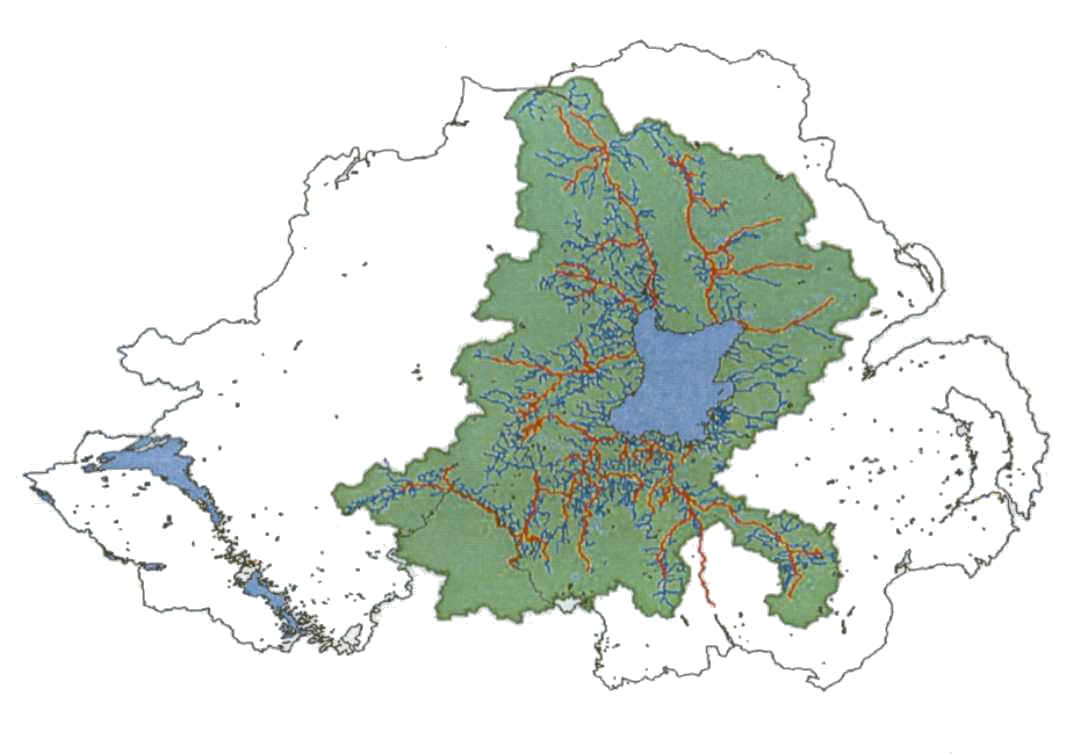
The Rivers Agency strives to keep the level within range but various factors outside their control can and do influence the level. The Lower Bann is capable of lowering Lough Neagh by 25-35mm per day but in times of heavy rainfall with the floodgates open the Lough can rise quite quickly. This is due to the fact that six major and various minor rivers flow into the Lough. This quick level rise usually only occurs during the winter months. The Lough Neagh catchments area is approximately 4836 sq km (over one third of Northern Ireland).The average total rainfall is in the region of 1000mm.
During the summer months the level of the Lough can fall from control level by over 400mm. This is caused by three factors, evaporation, water abstraction and the discharge into the Lower Bann via the fish pass at Toomebridge. The flow at the fish pass has a minimal effect on the levels.
To help compensate for the winter and summer changes the Rivers Agency varies the control level (within statute). Winter control (October to April inc.) is set at 12.475m O.D. and summer control (May to September) is set at 12.58m O.D.
Another temporary factor, which can change the level on the Lough, is wind and the level can change quite dramatically during a storm. After a storm for two or three days there is an effect called a seiche. This is best described as water slopping back and forwards in a large basin. It is not very noticeable (0-75mm period 30mins approx) but could be used to advantage if a vessel was aground. Many times grounded boats have been towed to no avail suddenly start moving with apparent ease.
The Admiralty publish a chart for Lough Neagh (no 2163) .The datum for this chart is 12.5m O.D. M.S.L. Belfast. Anyone using this chart for navigation is advised to check the current level of Lough Neagh before undertaking a passage. The level for Lough Neagh and the Lower Bann can be checked with Rivers Agency at Coleraine (028703 42357). The levels recordings are updated daily.
Current levels can be checked at https://www.infrastructure-ni.gov.uk/articles/lough-neagh-levels
Charges
There are no
charges or licence fees as such for boating on the system, however there
is usually a charge at the various slipways for launching. This varies
throughout the system . Berthing fees vary
from marina to marina. There are quite a few public jetties with no charge for an overnight
stay. Although there is an overnight charge at most of the marinas
on the system, at some it is not collected to encourage visitors. For
example at Kinnego Marina a year’s berth (any length) is £600 and an overnight
visit is free. There is a lock passage fee on the Lower Bann of £1 per lock
with a reduction to 50p if two craft or more go through together. The double
chamber at Portna is counted as one lock passage.
Insurance
Most local authorities insist on proof of minimum third party insurance before permission is granted to use their facilities.
Loughshore Trail
If room permits carrying a bicycle aboard can be a useful asset for visiting places of interest and collecting provisions etc. The newly opened Loughshore Trail is proving popular with local cyclists. A new bridge over the Blackwater River at Maghery was provided as part the trail.
The 120-mile Loughshore Trail, Route 94, is now signed, mapped and ready to cycle. This route encircles Lough Neagh. It can be followed in either direction and consists mainly of very quiet minor roads, with stretches of forest track and new paths near the Lough.
Attractions along the way include Toome Canal Walk with the Lock Keepers Cottage, Clotworthy House, Randalstown Viaduct, Cranfield Bay, the Old Cross at Ardboe, Peatlands Park, Oxford Island Visitor Centre and the towns of Crumlin and Glenavy, arriving at Antrim, via Rea's Wood. Local cyclists are benefiting from a new cycle track alongside the main road between Antrim and Randalstown and new route developments in Toome and Craigavon.
Navigation Authorities
The Navigation Authority for the Lower Bann Estuary from Coleraine Millennium Footbridge to the Barmouth is Coleraine Harbour Commissioners. Waterways Ireland is the Navigation Authority for the Lower Bann from the Footbridge to Toome Canal Entrance. There is no Statutory Navigation Authority for Lough Neagh although the local councils enforce rules and regulations in the vicinity of their marinas and facilities. Whilst under no statutory obligation the Department for Communities maintains the existing 47 Cardinal and Lateral Marks on Lough Neagh to assist navigation around the Lough Neagh shoreline. The Honourable the Irish Society owns the bed and soil of the Lower Bann. Shaftsbury Estates own the bed and soil of Lough Neagh and Craigavon Council own the bed and soil of Kinnego Bay. The River Bann and Lough Neagh Association and the Inland Waterways Association of Ireland are in full support of the creation of a Navigation Authority for Lough Neagh, the Upper Bann and the River Blackwater.
Waterways Ireland
Waterways Ireland is a North/South Implementation Body responsible for the management, maintenance, development and restoration of the inland navigable waterway system principally for recreational purposes.
Responsible for approximately 1000km of navigable waterways, Waterways Ireland manages the Barrow Navigation, the Erne System, the Grand Canal, the Lower Bann, the Shannon River, the Shannon Erne Waterway and the Royal Canal.
Waterways Ireland is headquartered in Enniskillen, with offices in Dublin, Scarrif and Carrick-on Shannon. Waterways Ireland has three regions. The Northern Region includes the Erne System, the Shannon Erne Waterway and the Lower Bann and is based in Carrick-on Shannon. The Eastern Region is based in Dublin and is responsible for the Grand Canal, the Royal Canal and the Barrow Navigation. The Western Region is based in Scarrif and is responsible for the Shannon River and the extension to the navigations into Lough Allen, extensions up the River Suck to Ballinasloe and from Lough Key towards Boyle.
Waterways Ireland was also charged with taking forward studies and appraisals in relation to the possible restoration of the Ulster Canal. These studies are complete and rest with the Sponsoring Departments; the Department of Culture, Arts and Leisure (Northern Ireland) and Department of Community, Rural and Gaelteacht Affairs (Republic of Ireland). Further to this Waterways Ireland have been asked to report on the study with model funding options for the development of the Ulster Canal.
A wide range of information is available on all of the inland navigations under Waterways Ireland remit. To receive information and for any other queries contact Waterways Ireland on
5-7 Belmore St
Enniskillen
Co Fermanagh
BT74 6AA
Tel no 028 6634 3004
Fax no 028 6634 6257
E-mail info@waterwaysireland.org
www.waterwaysireland.org
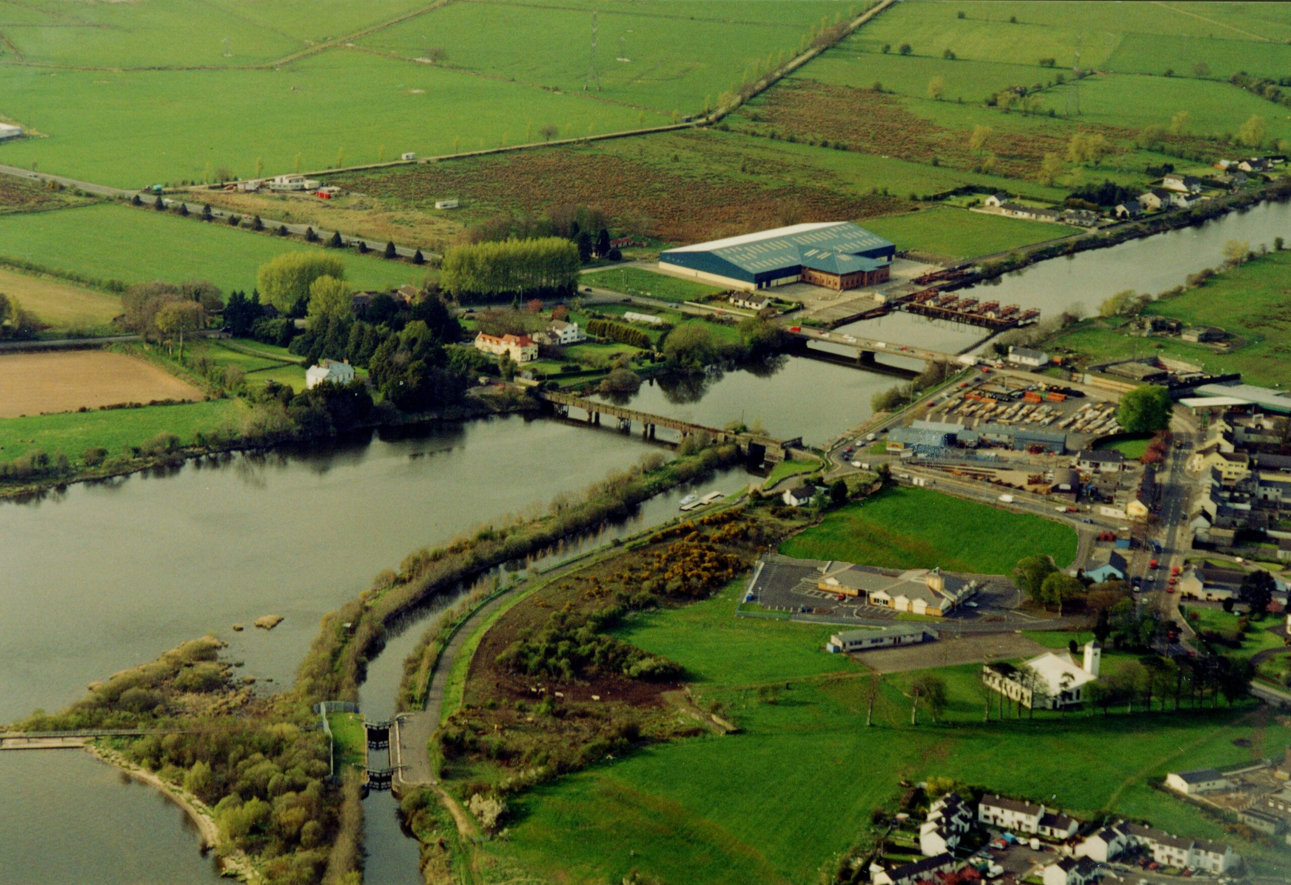
Toomebridge
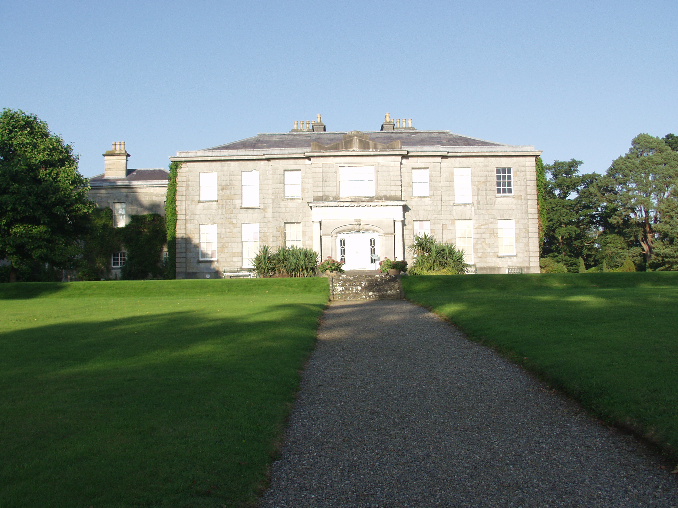
The Argory on the River Blackwater
created with
WordPress Builder .